


U2020 La rochepot 23/06/2020

clabidault
User
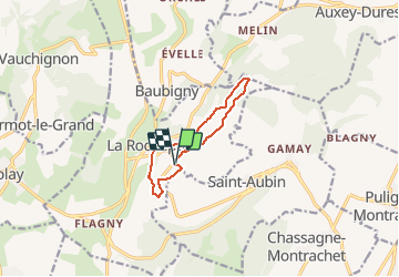

Length
8.9 km

Max alt
486 m

Uphill gradient
192 m
Km-Effort
11.5 km

Min alt
390 m

Downhill gradient
183 m
Boucle
Yes
Creation date :
2020-03-11 12:43:51.339
Updated on :
2020-06-19 19:01:58.918
--
Difficulty : Very easy

FREE GPS app for hiking
 SityTrail
IGN / Geographical institutes
SityTrail Plus
The world is yours!
About
Trail On foot of 8.9 km to be discovered at Bourgogne-Franche-Comté, Côte-d'Or, La Rochepot. This trail is proposed by clabidault.
Positioning
Country:
France
Region :
Bourgogne-Franche-Comté
Department/Province :
Côte-d'Or
Municipality :
La Rochepot
Location:
Unknown
Start:(Dec)
Start:(UTM)
628320 ; 5201395 (31T) N.
Comments